Earthquakes
July 4, 2024 - Reading time: ~1 minute
Earthquakes abs seismic shadow
There is a predictable area of stations that won't see any p waves because they're blocked by the core. This can't be explained on flat earth.
Time Zones
July 4, 2024 - Reading time: ~1 minute
At the poles, people can just pick a time zone that works for them. It's not that big of a deal.
Horizon
July 4, 2024 - Reading time: ~1 minute
Horizon doesn't rise to eye level
https://youtu.be/NqOQ_BCtqUI?si=7i84gOyUzxAMu6zP Proof. Going to do it myself someday.
Satellites
July 4, 2024 - Reading time: 2 minutes
ISS
50 minute iss video tour There's no balloon attached to the plethora of amateur pictures of iss
Parallax calculation 1
We can use angles given to us for DirecTV WorldDirect (95W, 101W) based on maps to see if the position makes sense geometrically.
Sandpoint, ID
Latitude: 48.4194° Longitude: -116.5300° Height: 0.9KM
Satellite: DirecTV WorldDirect (95W, 101W) Elevation: 30.6° Azimuth (true): 152.2° Azimuth (magn.): 138.1°
Chile
Latitude: -35.6751° Longitude: -71.5430°
Satellite: DirecTV WorldDirect (95W, 101W) Elevation: 41.7° Azimuth (true): 323.4° Azimuth (magn.): 320.7°
Calculation
Here's a link to the simulation page.

Parallax calculation 2
Different satellite - the one everyone seems to use in the US for DirecTV.
Sandpoint, ID (ZIP 83864)
Latitude: 48.4194° Longitude: -116.5300°
Satellite: 110W & 119W Elevation: 34.4° Azimuth (true): 177.3° Azimuth (magn.): 163.2°
Anchorage, AK (ZIP 99504)
Latitude: 61.2042° Longitude: -149.7379°
Satellite: 110W & 119W Elevation: 14.8° Azimuth (true): 141.1° Azimuth (magn.): 126.3°
Calculation
Here's a link to the simulation page.
Railroads
July 4, 2024 - Reading time: 2 minutes
Railroads don't follow a curve
1837 book on railroad building
A treatise on the Principles and Practice of Leveling
ON THE PRINCIPLES OF LEVELLING.
LEVELLING is the art of tracing a line at the surface of the earth which shall cut the directions of gravity everywhere at right angles. If the earth were an extended plane, all lines representing the direction of gravity at every point on its surface would be parallel to each other; but, in consequence of its figure being that of a sphere or globe (The figure of the earth is not exactly that of a sphere, but of an oblate spheroid flattened at the poles; the length of the equatorial diameter being 7924 miles, and that of the polar diameter 7898 miles. For our present purpose, it is sufficiently correct to consider it as a sphere.), they everywhere converge to a point within the sphere which is equidistant from all parts of its surface; or, in other words, the direction of gravity invariably tends towards the centre of the earth, and may be considered as represented by a plumb-line when hanging freely, and suspended beyond the sphere of attraction of the surrounding objects."
After that he derives the 8 inches per mile squared approximation in a really nice way.
Also gives a good equation approximation for feet!
2D^2/3
So 10 miles would be 200/3 = 66 feet
Book then talks about refraction, provides a practical correction of 1/7th.
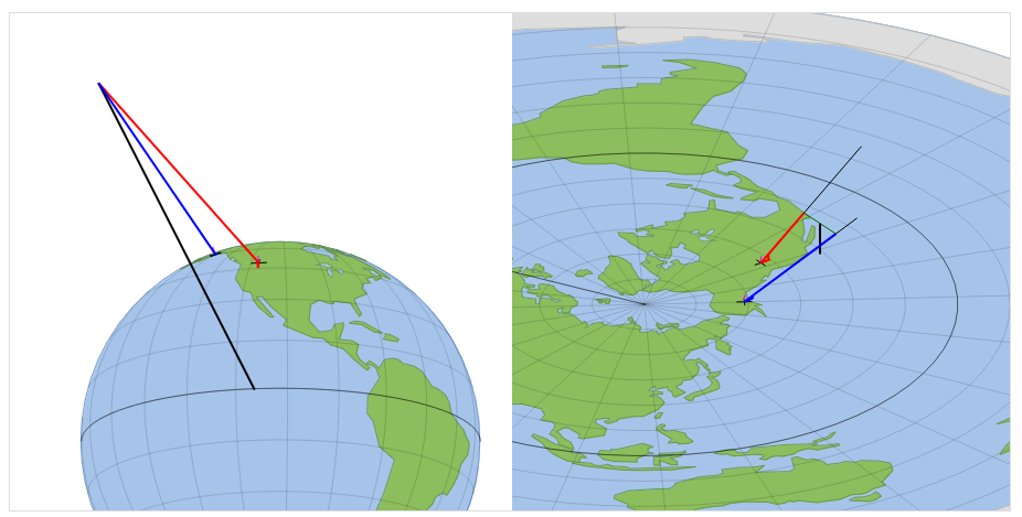
Antarctica
July 4, 2024 - Reading time: 3 minutes
Antarctic Boat Race
There's a race where they circumnavigate Antarctica. https://www.sail-world.com/Australia/Antarctica-Cup-Yacht-Race/-36654?source=google
Do they turn towards Antarctica, track straight or away from an ice wall? Flat earth would be away from it.
Takes about 100 days
https://www.sail-world.com/Australia/Fedor-Konyukhov-sets-Antarctica-record/-44187?source=google
At 66,5 N or S. the circumference is 8,620 nm or 16.000 , on a Flat Earth at 66.5˚S it would be 19,800 nm. or 37,000 km. So the race proves Earth is a spheroid.
37,000km in 100 days would be 370km/day, 15km/h average. Roughly double average cruising speed.
Bislins has a ton of data you can run in his visualizations from boat races like this: Link
Antarctica imagery
You can download landsat mosaics here https://lima.usgs.gov/fullcontinent.php
ANTHROPOGEOS
https://antarctica.anthropogeos.com/en/introduction
IN THE 2019-2020 SEASON, THE ANTHROPOGEOS TEAM WENT ON AN EXPEDITION ACROSS THE CONTINENT, JOINING THE COLONIALIST MOVEMENT. THIS TRIP BECAME THE BASIS FOR THE PROJECT ANTARCTICA. THE LAST COLONIZATION. WE DROVE 4500 KM THROUGH THE WHITE DESERT AND WE WANT TO SHARE OUR EXPERIENCE, AS WELL AS EXPLORING THE INS AND OUTS OF TOURISM AND LIFE IN ANTARCTICA.
They used Arctic trucks, one of the three tourism agencies allowed to operate in Antarctica.
https://arctictrucks.com/polar/
https://www.arctictrucks-experience.com/antarctica/
http://antarcticachallenge.com/antarctica-crossing/
Further Research
- They only let you travel there in summer, so no stargazing. Need a star trail video from the geographic pole straight up uncut. Would have to get from one of the thousand or so winter inhabitants.