Measuring Earth
August 31, 2024 - Reading time: ~1 minute
You can measure the Earth with stuff you already have and a short trip!
Satellite Internet
August 17, 2024 - Reading time: ~1 minute
Imagine you're the Hughes corporation. NASA comes to you, says "We both know the Earth is flat, but we need you to spend billions of dollars figuring out how to keep a balloon in the same position for decades to offer internet to people. Now, the balloon will of course be inside the atmosphere exposed to wind, but it cannot move so it'll need some sort of thrusters to keep it in place. Also, we have to simulate the latency of all the internet as if it's served by a geostationary satellite, so make it extremely slow and annoying to use." Hughes complies:
https://en.m.wikipedia.org/wiki/Hughes_Network_Systems
They also somehow simulate the position of the balloon such that the parallax places it where a geostationary satellite would be instead of a balloon. See Satellites
What is more likely? This story, or geostationary satellites existing?
Azimuthal Equidistant Maps
August 14, 2024 - Reading time: 2 minutes
I just had a realization that azimuthal equidistant maps work in radio regardless of where they are centered. this is only possible on a sphere. On a disc that would not be the case because of the ice wall. Radio helps prove globe Earth again.
OK I thought about it more and found this great website:
https://maps.ontarget.cc/azmap/en.html
If we generate a map for Australia, we get this:
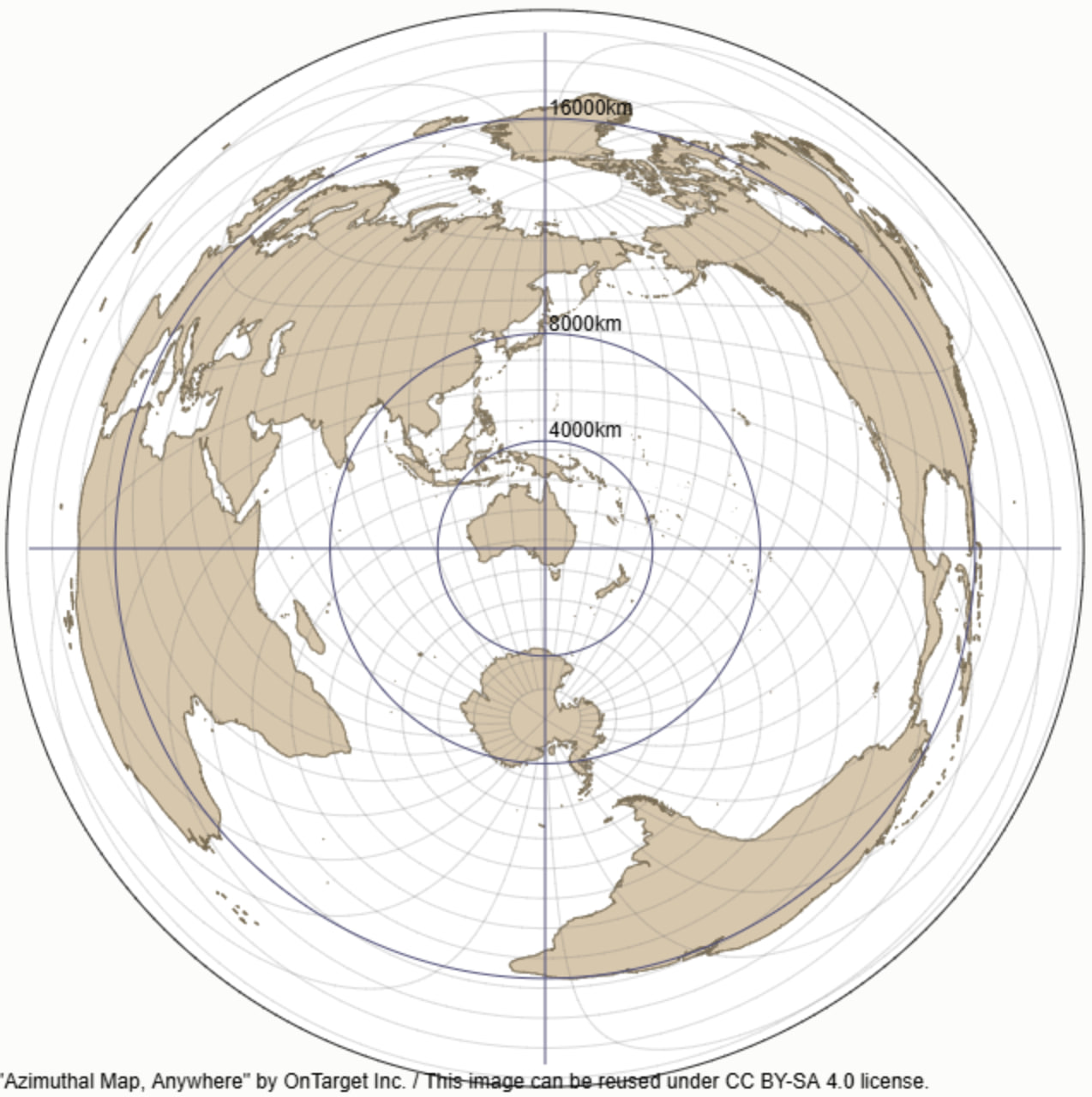
If we can find an Australian with a beam antenna, he will likely have bearings for signals recorded in his logbook. Conversations to Brazil would of course be best if pointed over the southern pole according to this map. We could aggregate all the QSOs between Australia and Brazil with bearing information, and create a map showing it. The radio operators aren't in on anything - it's uncontrolled data from thousands (or tens of thousands) of people. It's just a matter of getting the dataset that's the hard part.
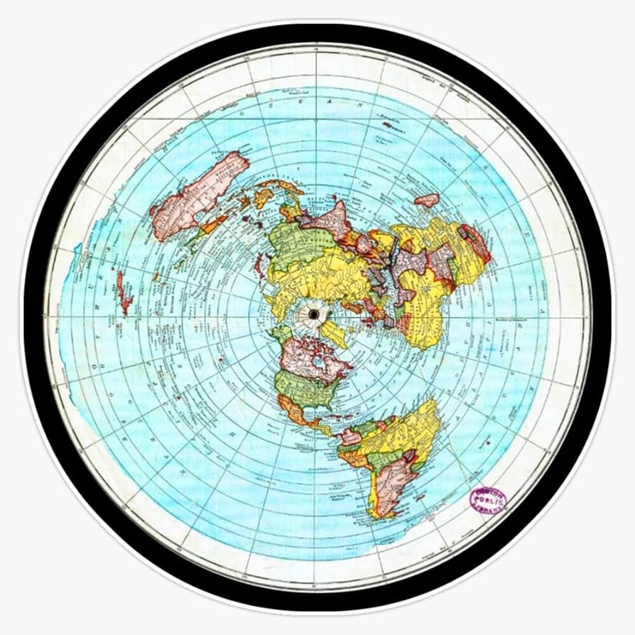
On the disc map, we see that the optimal path is much further and entirely the other way (over the north pole):
Earthrise Photos
August 12, 2024 - Reading time: 3 minutes
2015 Earthrise
This one is very interesting and I have to thank a friend (you know who you are) for bringing it to my attention! So there's a video here showing some photoshop levels tools being used on some images. I had no idea what images these were, so I tracked them down. I found quite a few examples of this image that didn't have the artifacts shown in the video, so I started to suspect the guy who made it. But then I found this post which pointed to a copy on Wikimedia Commons.
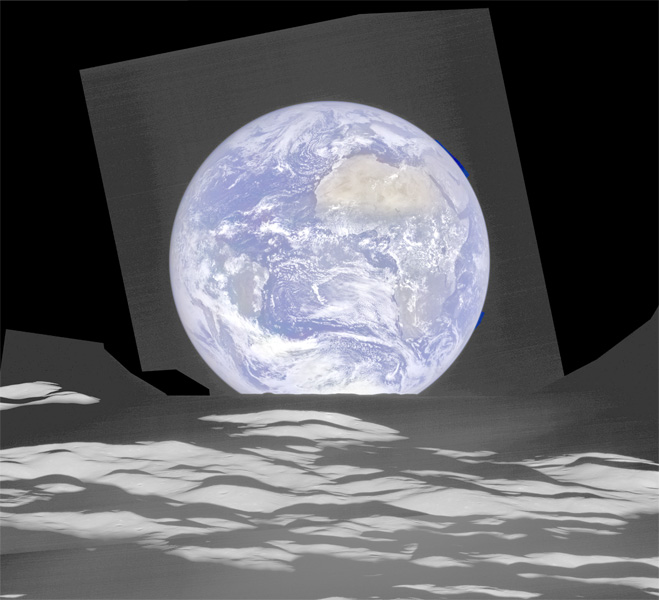
It appears it is a composite image! But why?! Perhaps there's trickery afoot!
I finally tracked this down showing what they were saying in 2015 about this photo. It matches exactly what the pages say now.
This image was composed from a series of images taken Oct. 12, when LRO was about 83 miles (134 kilometers) above the moon's farside crater Compton. Capturing an image of the Earth and moon with LRO's Lunar Reconnaissance Orbiter Camera (LROC) instrument is a complicated task. First the spacecraft must be rolled to the side (in this case 67 degrees), then the spacecraft slews with the direction of travel to maximize the width of the lunar horizon in LROC's Narrow Angle Camera image. All this takes place while LRO is traveling faster than 3,580 miles per hour (over 1,600 meters per second) relative to the lunar surface below the spacecraft!
The high-resolution Narrow Angle Camera (NAC) on LRO takes black-and-white images, while the lower resolution Wide Angle Camera (WAC) takes color images, so you might wonder how we got a high-resolution picture of the Earth in color. Since the spacecraft, Earth, and moon are all in motion, we had to do some special processing to create an image that represents the view of the Earth and moon at one particular time. The final Earth image contains both WAC and NAC information. WAC provides the color, and the NAC provides high-resolution detail.
It has always been called a composite image. Nothing was ever hidden about it. They overlayed the color from another sensor on top of the monochrome.
History
July 16, 2024 - Reading time: ~1 minute
Mercator
In 1569 Mercator put the world Globe directly in his map name.
https://en.m.wikipedia.org/wiki/Mercator_1569_world_map
The entire reason the projection needs to exist is to flatten a sphere.
In making this representation of the world we had three preoccupations. Firstly, to spread on a plane the surface of the sphere in such a way that the positions of places shall correspond on all sides with each other both in so far as true direction and distance are concerned and as concerns correct longitudes and latitudes; then, that the forms of the parts be retained, so far as is possible, such as they appear on the sphere. With this intention we have had to employ a new proportion and a new arrangement of the meridians with reference to the parallels.
Jokes
July 4, 2024 - Reading time: ~1 minute
If the earth was flat, NPR wouldn't need hundreds of FM stations to turn kids into trannies!